49 Interesting Geography of Italy Facts (+free infographic)
Did you know that 76.8% of Italy was made of mountains and hills?
Or that Italy is the 6th most populated country in Europe?
Learn more about this European country with these 49 geography facts about Italy!
From rivers & volcanoes to regions & cities, you’ll also get a free infographic with all the information!
Quick Geography Facts of Italy
You’ll find below a few general geography facts of Italy, to learn more about this European country:
- Name: Italy | Italia (Italian)
- Full Name: Italian Republic | Repubblica Italiana
- Capital: Rome
- Land area: 301,340 km² / 116,350 square miles
- Population: 60.2 million
- Name of inhabitants: Italian
- Website: Italia
Where is Italy Located on the World Map?
Italy is located in Western Europe, south of Switzerland and south east of France.
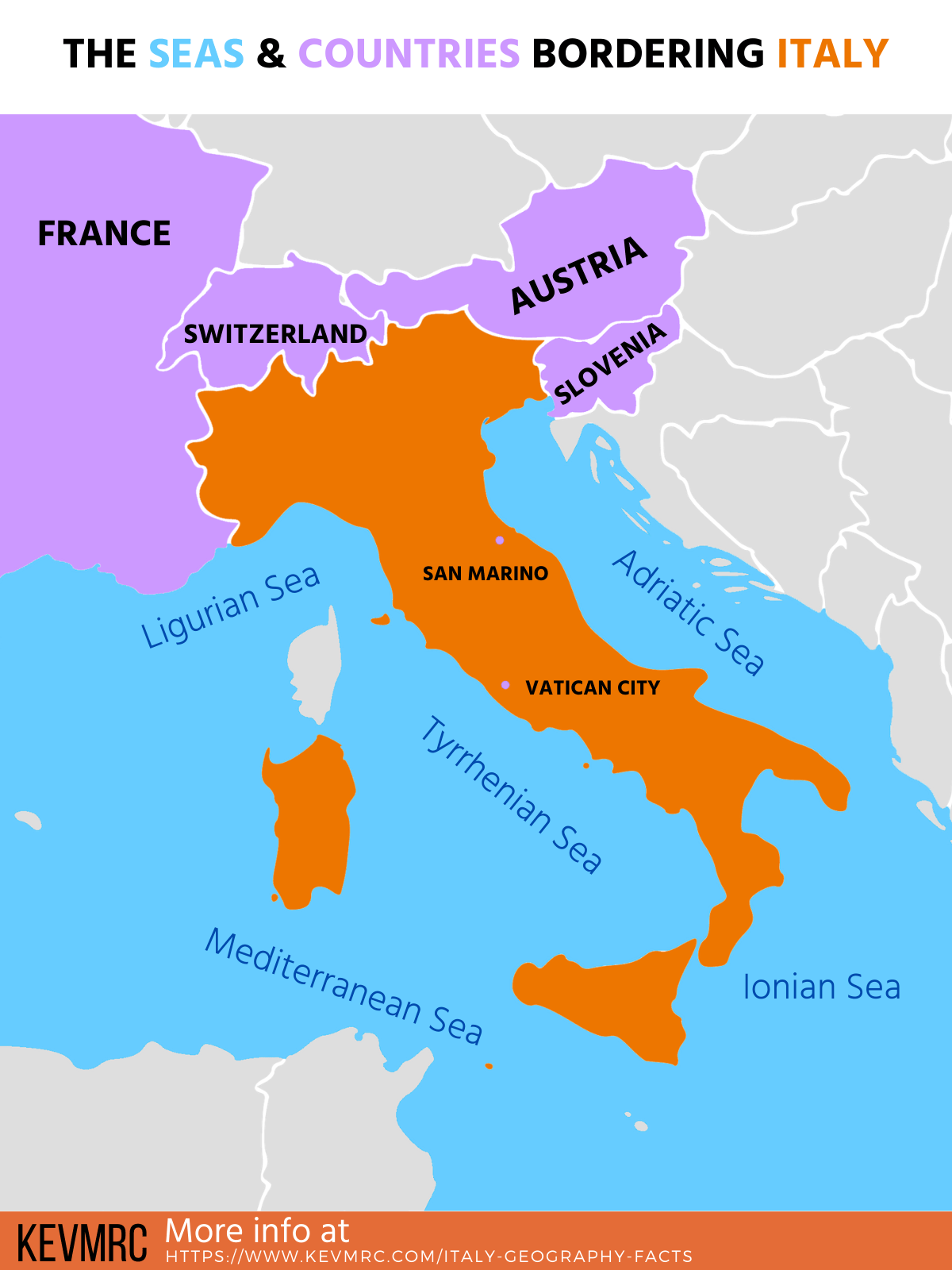
It shares borders with 6 countries, and it’s surrounded by 5 seas.
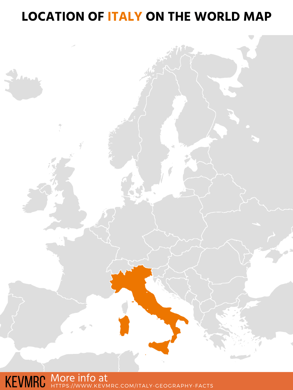
As you can see on the map above, Italy is shaped like a boot. The boot-shaped peninsula is often referred to as “the boot”, or “lo stivale” in Italian.
Countries bordering Italy:
- Austria – north east
- France – north west
- San Marino – within Marche region
- Slovenia – north east
- Switzerland – north
- Vatican City – within Rome
Seas surrounding Italy:
- Adriatic Sea – north east
- Ionian Sea – south east
- Tyrrhenian Sea – east
- Ligurian Sea – north west
- Mediterranean Sea – south
Now that you’ve learned about the general facts about Italy geography, let’s dive straight in the main facts!
The Main Italy Geography Facts
Let’s start with the main Italy geography facts. In this part, you’ll find information about the first type of geography: physical geography.
Physical geography is about the study of the natural characteristics of the earth. Below you’ll find facts & info about rivers, lakes, mountains, volcanoes and islands.
1. Italy total area is 301,340 km² (116,348 square miles), making it the 10th biggest country in Europe, and 73rd in the world
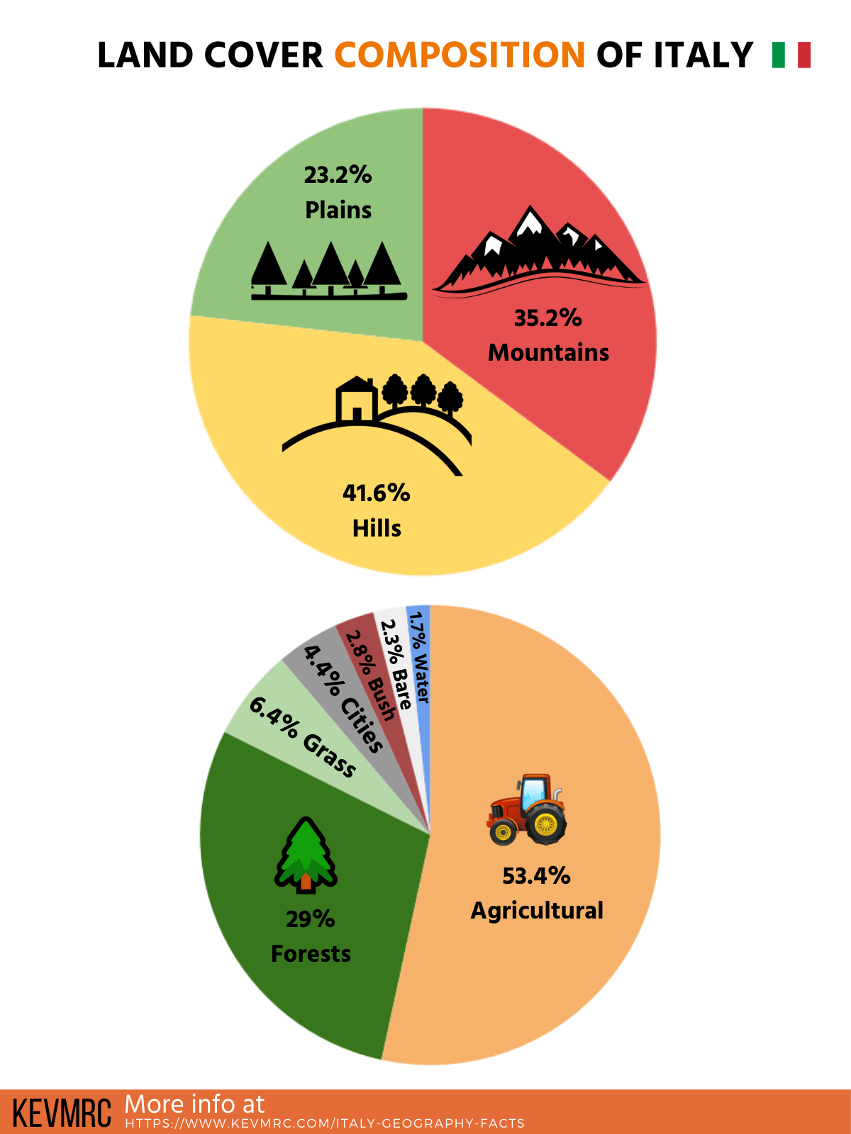
2. 76.8% of Italy is covered by mountains
3. 35.2% of the territory is made of mountains over 600m (1,968 feet), and 41.6% of hills (below 600m)
4. Only 1.7% of Italy is made of water (lakes, rivers, swamps, …)
5. Italy has 7,600 km of coastline (4,722 miles), ranking 15th in the world after Mexico and before India
6. Mountains account for 35.2% of Italian territory
7. The total border length of Italy is 1,836 km (1,141 miles)
Let’s see in more details the different natural elements of Italy.
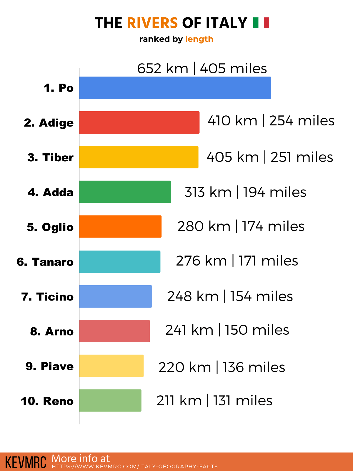
The Rivers of Italy
This part is dedicated to the rivers of Italy: facts, location of the main rivers, and ranking of the biggest rivers in Italy.
8. There are more than 1,000 rivers in Italy
9. The most famous river is probably the Tiber river as it passes through Rome, but it’s only the 3rd biggest in Italy
10. The longest river in Italy is the Po River, and it’s 652 km long (405 miles)
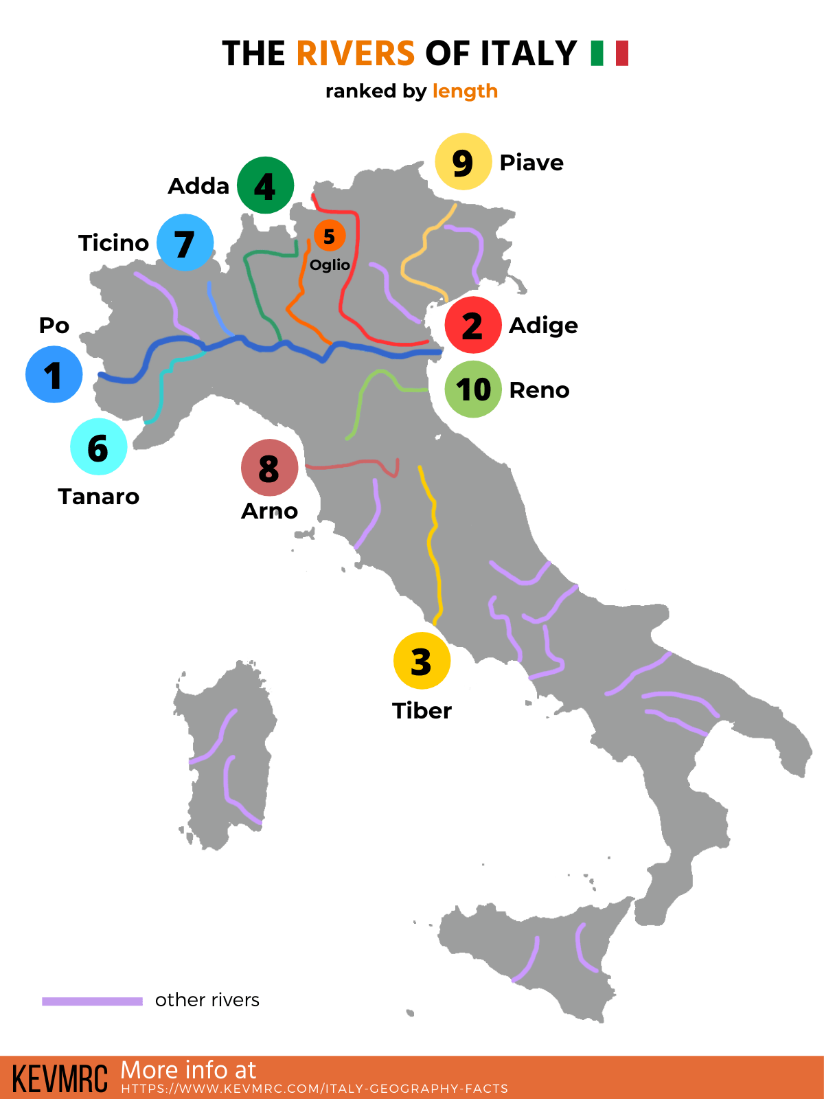
The 10 biggest rivers in Italy:
- Po: 652 km | 405 miles
- Adige: 410 km | 254 miles
- Tiber: 405 km | 251 miles
- Adda: 313 km | 194 miles
- Oglio: 280 km | 174 miles
- Tanaro: 276 km | 171 miles
- Ticino: 248 km | 154 miles
- Arno: 241 km | 150 miles
- Piave: 220 km | 136 miles
- Reno: 211 km | 131 miles
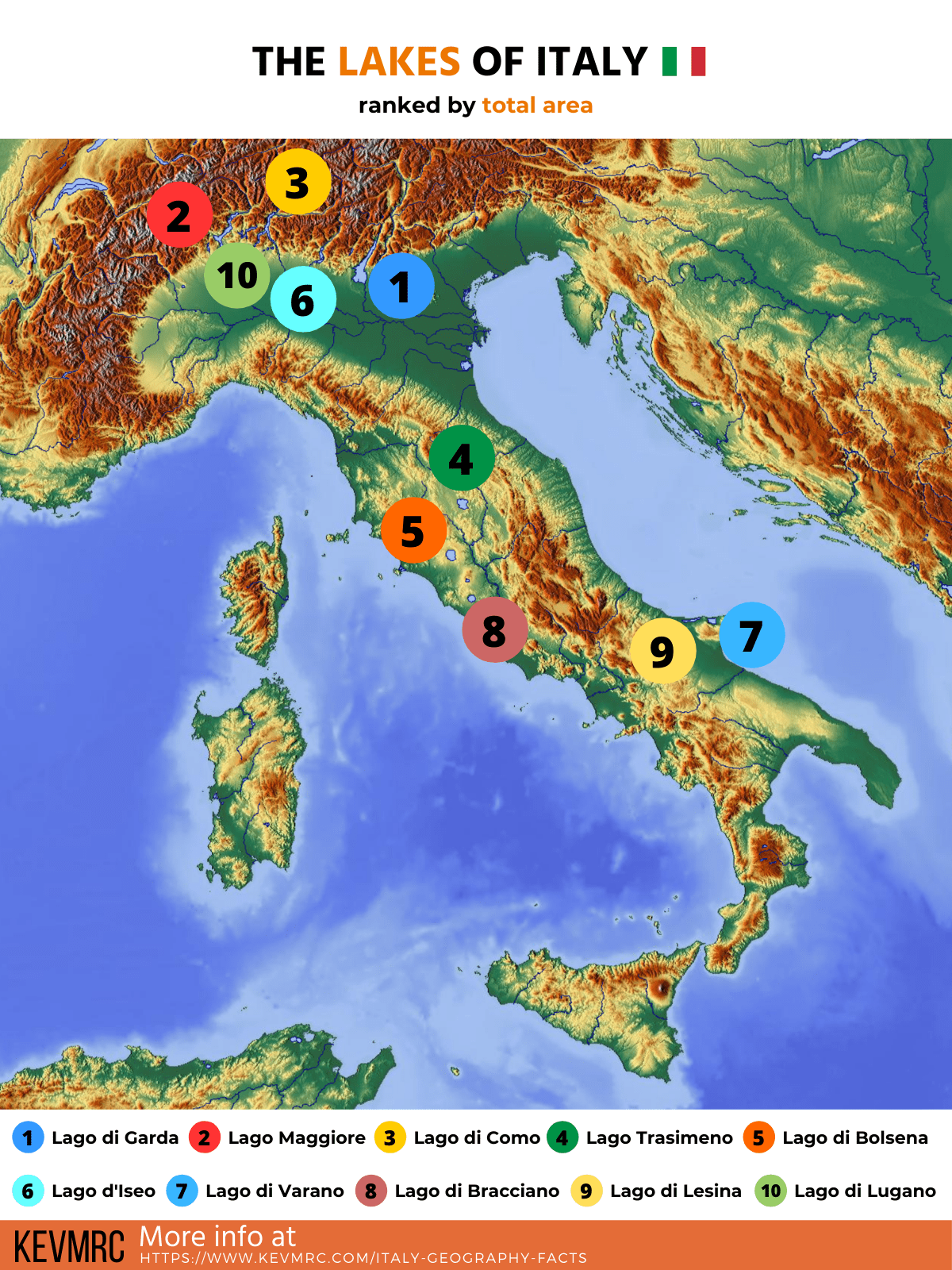
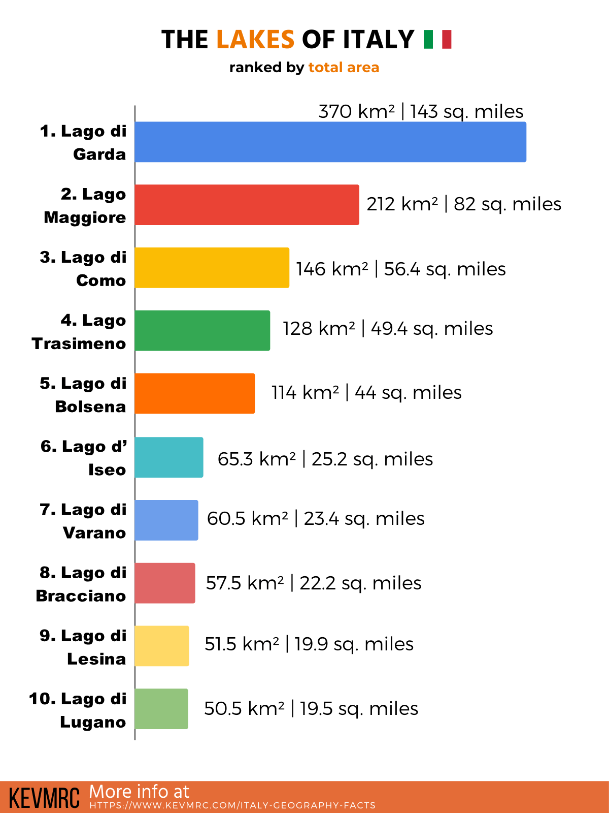
The Lakes of Italy
This part is dedicated to the lakes of Italy: facts, location of the main lakes, and ranking of the biggest lakes in Italy.
11. There are more than 1,500 in Italy
12. Lago di Gardo, or Lake Garda, is the largest lake in Italy; but it’s only the 3rd deepest
13. The deepest lake in Italy is Lago di Como, with a depth of 410 meters (1,345 feet)
14. Lake Garda belongs to 3 different provinces: Verona, Brescia and Trento
15. The longest lake in Italy is Lake Maggiore, with a length of 64 km (40 miles)
16. Lake Maggiore is located at 80% in Italy, and 20% in Switzerland
The 10 biggest lakes in Italy:
- Lago di Garda: 370 km² | 143 square miles
- Lago Maggiore: 212 km² | 82 square miles
- Lago di Como: 146 km² | 56.4 square miles
- Lago Trasimeno: 128 km² | 49.4 square miles
- Lago di Bolsena: 114 km² | 44 square miles
- Lago d’Iseo: 65.3 km² | 25.2 square miles
- Lago di Varano: 60.5 km² | 23.4 square miles
- Lago di Bracciano: 57.5 km² | 22.2 square miles
- Lago di Lesina: 51.5 km² | 19.9 square miles
- Lago di Lugano: 50.5 km² | 19.5 square miles
Italian Mountain Ranges
This part is dedicated to the mountains of Italy: facts, location of the main mountains, and ranking of the tallest peaks in Italy.
17. There are 2 main mountain ranges in Italy: the Alps and the Apennines
18. Mont Blanc is the highest mountain in Italy, at 4,808 meters (15,774 feet)
19. The Mont Blanc is also the highest peak in Europe
20. More than the 150 highest peaks in Italy are all located in the Alps
21. The Italian Alps have 3 main parts: Western Alps, Central Alps and Eastern Alps
22. The Dolomites, a famous tourist destination, are part of the Eastern Alps
23. The Mont Blanc peak is on the border between Italy and France, and belongs to the 2 countries
24. The Apennine mountain range is the longest mountain range in Italy, stretching over 1,500 km (932 miles)
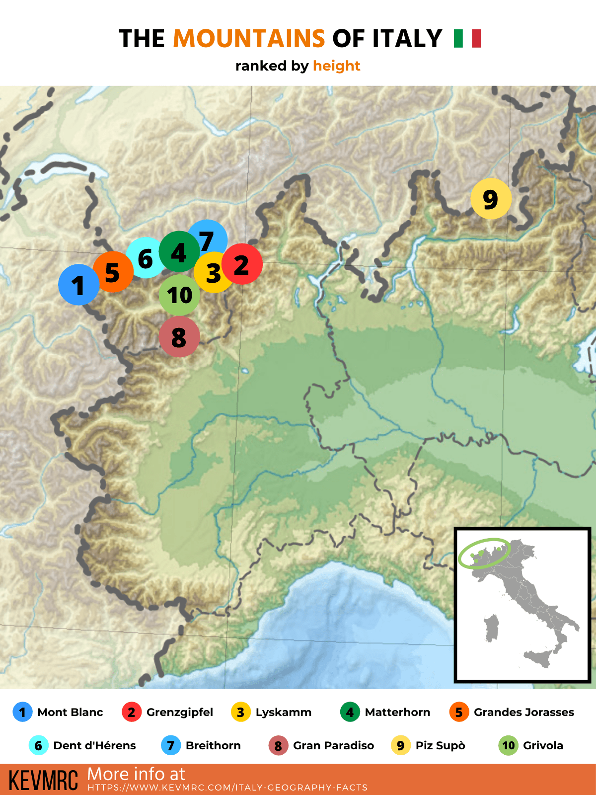
The 10 highest mountains in Italy:
- Mont Blanc / Monte Bianco: 4,808 meters | 15,774 feet
- Grenzgipfel / Monte Rosa: 4,618 meters | 15,154 feet
- Lyskamm / Silberbast: 4,527 meters | 14,852 feet
- Matterhorn / Monte Cervino: 4,478 meters | 14,691 feet
- Grandes Jorasses: 4,208 meters | 13,805 feet
- Dent d’Hérens: 4,171 meters | 13,684 feet
- Breithorn: 4,164 meters | 13,661 feet
- Gran Paradiso: 4,061 meters | 13,323 feet
- Piz Supò: 3,996 meters | 13,110 feet
- Grivola: 3,969 meters | 13,021 feet
Volcanoes in Italy
This part is dedicated to the volcanoes of Italy: facts, location of the main volcanoes, and ranking of the tallest volcanoes in Italy.
25. There are 48 volcanoes in Italy
26. Mount Etna is the highest volcano in Italy, peaking at 3,329 meters (10,922 feet)
27. Italy has 3 active volcanoes: Mount Etna, Mount Vesuvius, and Stromboli
28. Mount Vesuvius is the only active volcano in mainland Europe, located next to Naples
29. Marsili is the 2nd tallest volcano in Italy, but it’s completely under the sea
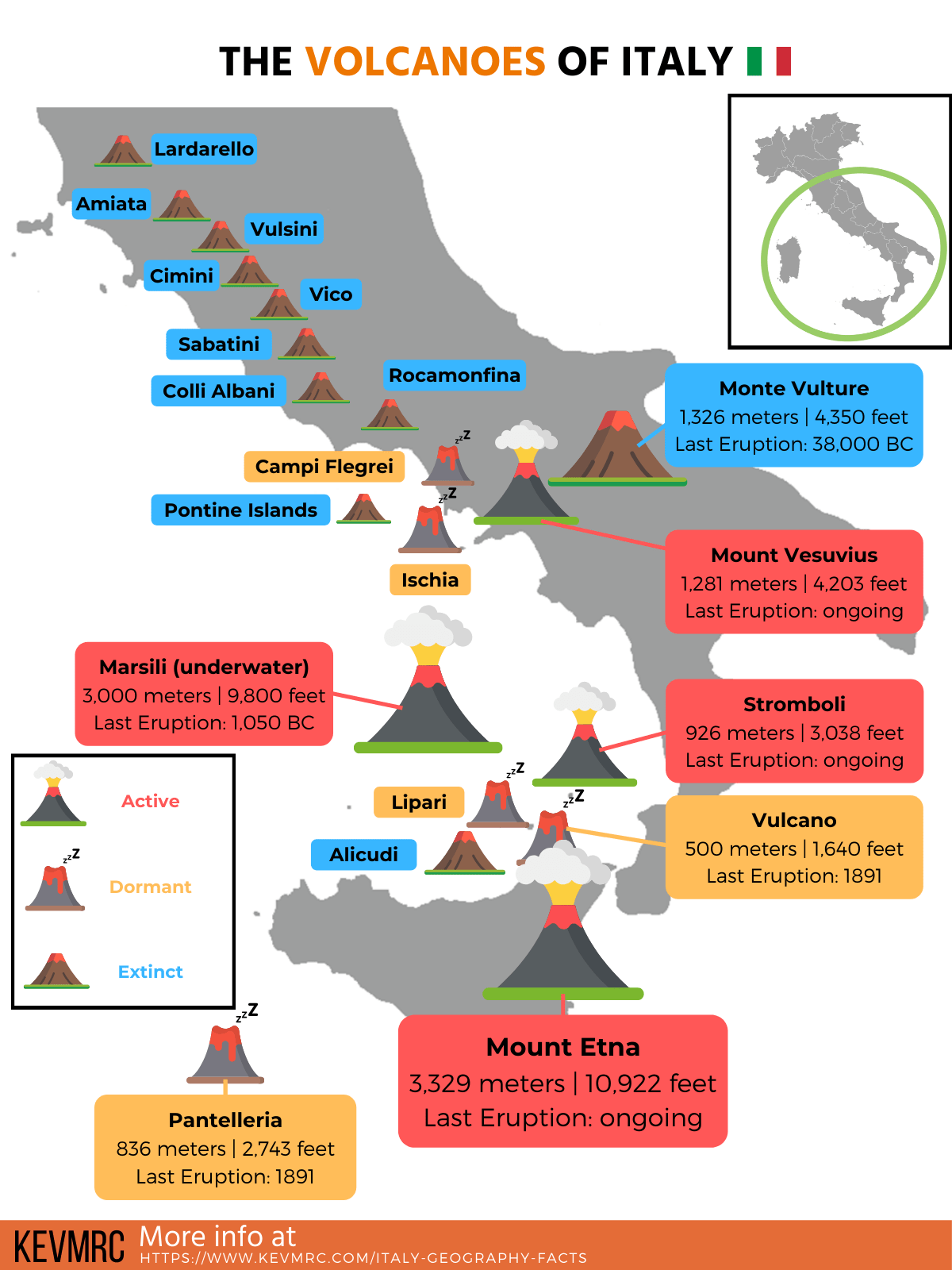
The 10 biggest volcanoes in Italy:
- Mount Etna: 3,329 meters | 10,922 feet
- Marsili: 3,000 meters | 9,800 feet (-450 meters / -1,476 feet below sea level)
- Amiata: 1,738 meters | 5,702 feet
- Monte Vulture: 1,326 meters | 4,350 feet
- Mount Vesuvius: 1,281 meters | 4,203 feet
- Cimini Hills: 1,053 meters | 3,454 feet
- Roccamonfina: 1,005 meters | 3,297 feet
- Monte Lauro: 986 meters | 3,117 feet
- Salina: 965 meters | 3,166 feet
- Vico: 965 meters | 3,120 feet
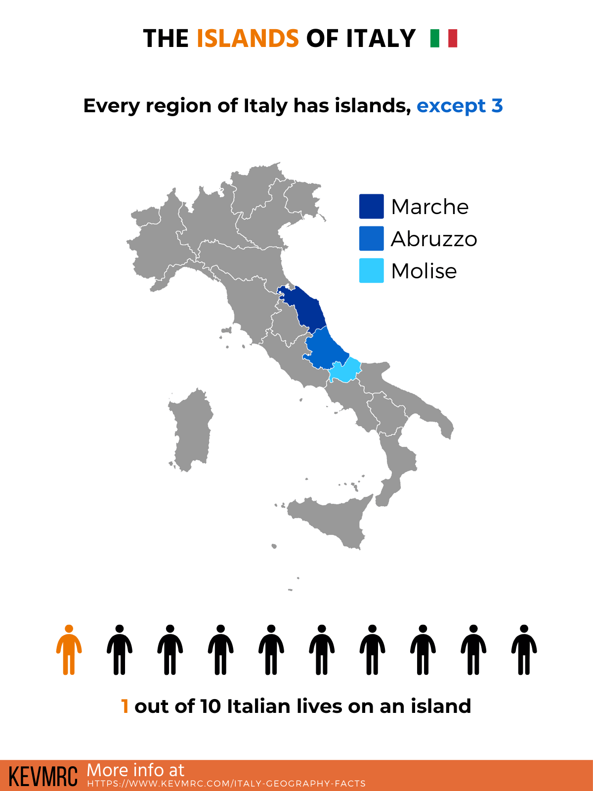
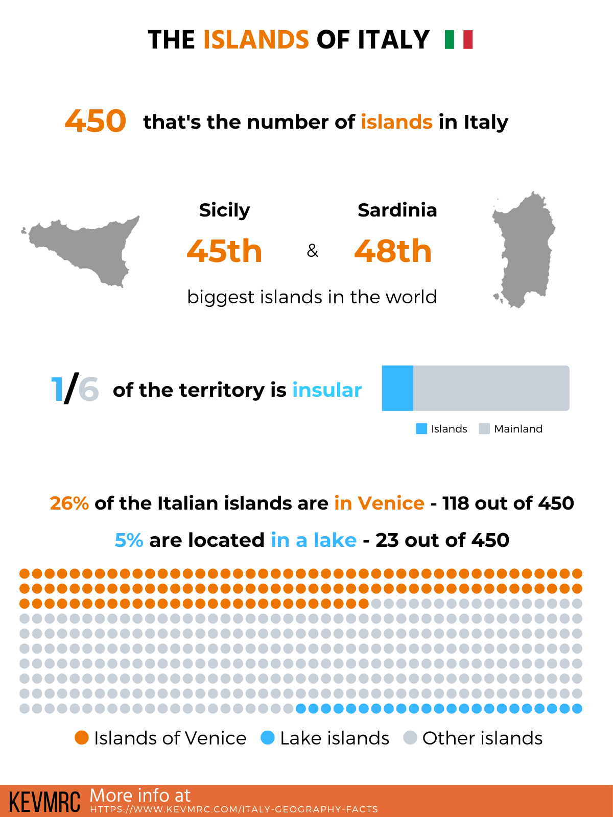
Italian Islands
And finally, the last part of physical geography is dedicated to the islands of Italy: facts, location of the main islands, and ranking of the biggest islands in Italy.
30. There are around 450 islands in Italy
31. Sicily is the biggest island in Italy, and the biggest island in the Mediterranean Sea
32. 1/4 of the islands are located in Venice, which is made of 118 islands
33. Islands make for 1/6 of the total area of Italy, but only 1/10 of the total population
The 10 biggest islands in Italy:
- Sicily: 25,662 km² | 9,908 square miles
- Sardinia: 24,090 km² | 9,300 square miles
- Elba: 224 km² | 86 square miles
- Sant’Antioco: 115.6 km² | 44.6 square miles
- Pantelleria: 83 km² | 32 square miles
- Asinara: 52 km² | 20 square miles
- San Pietro: 51 km² | 19.7 square miles
- Ischia: 46 km² | 18 square miles
- Lipari: 37 km² | 14 square miles
- Salina: 26 km² | 10 square miles
So there you have it, information & facts about the physical geography of Italy! Now let’s focus on the second type of geography: human geography.
Facts about the People of Italy
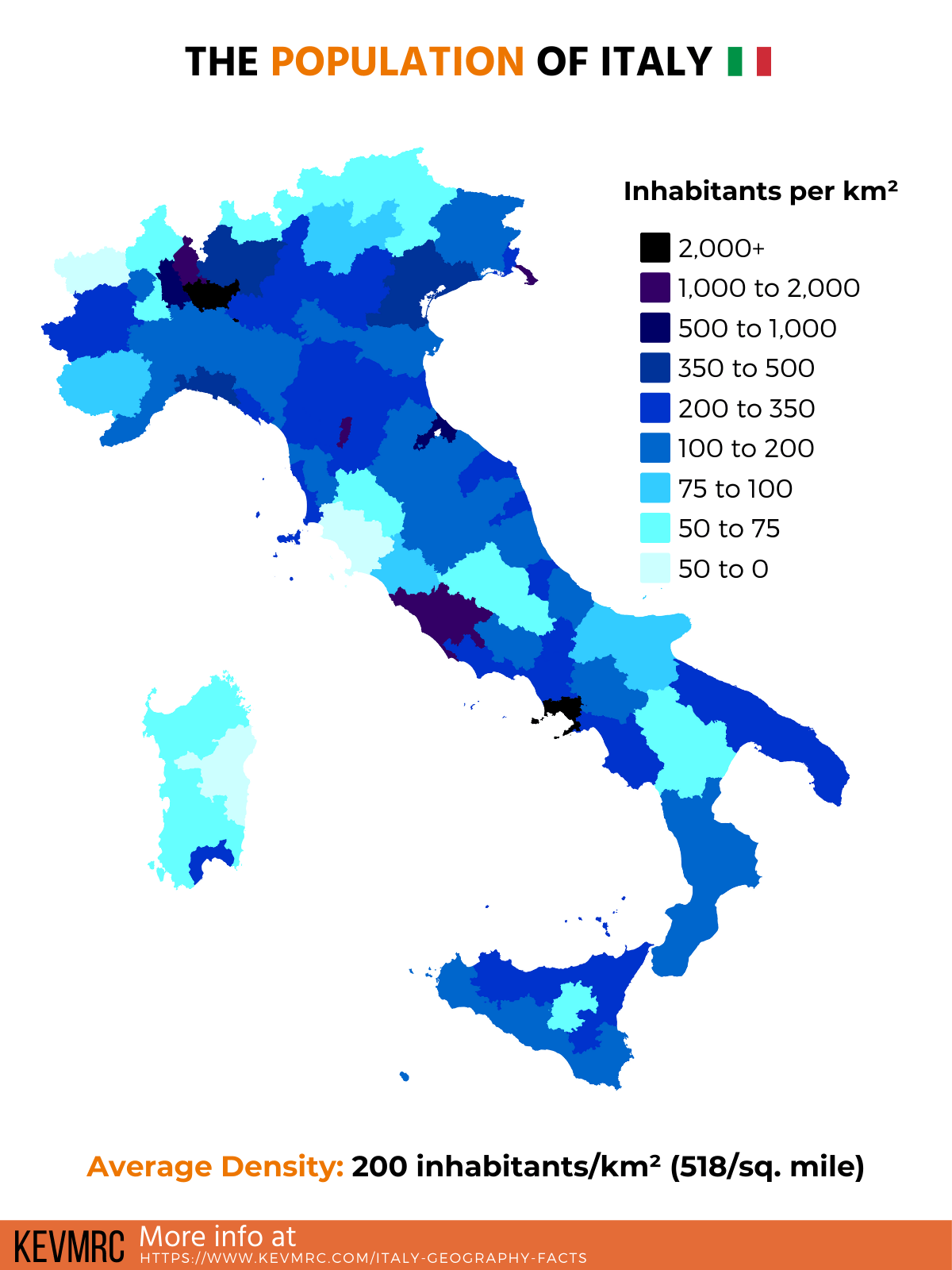
Human geography is the study of the human race. In this second part, we’ll see all about the Italians, inhabitants of Italy.
From population size and population density, to the repartition of the population across the country, in various regions & cities.
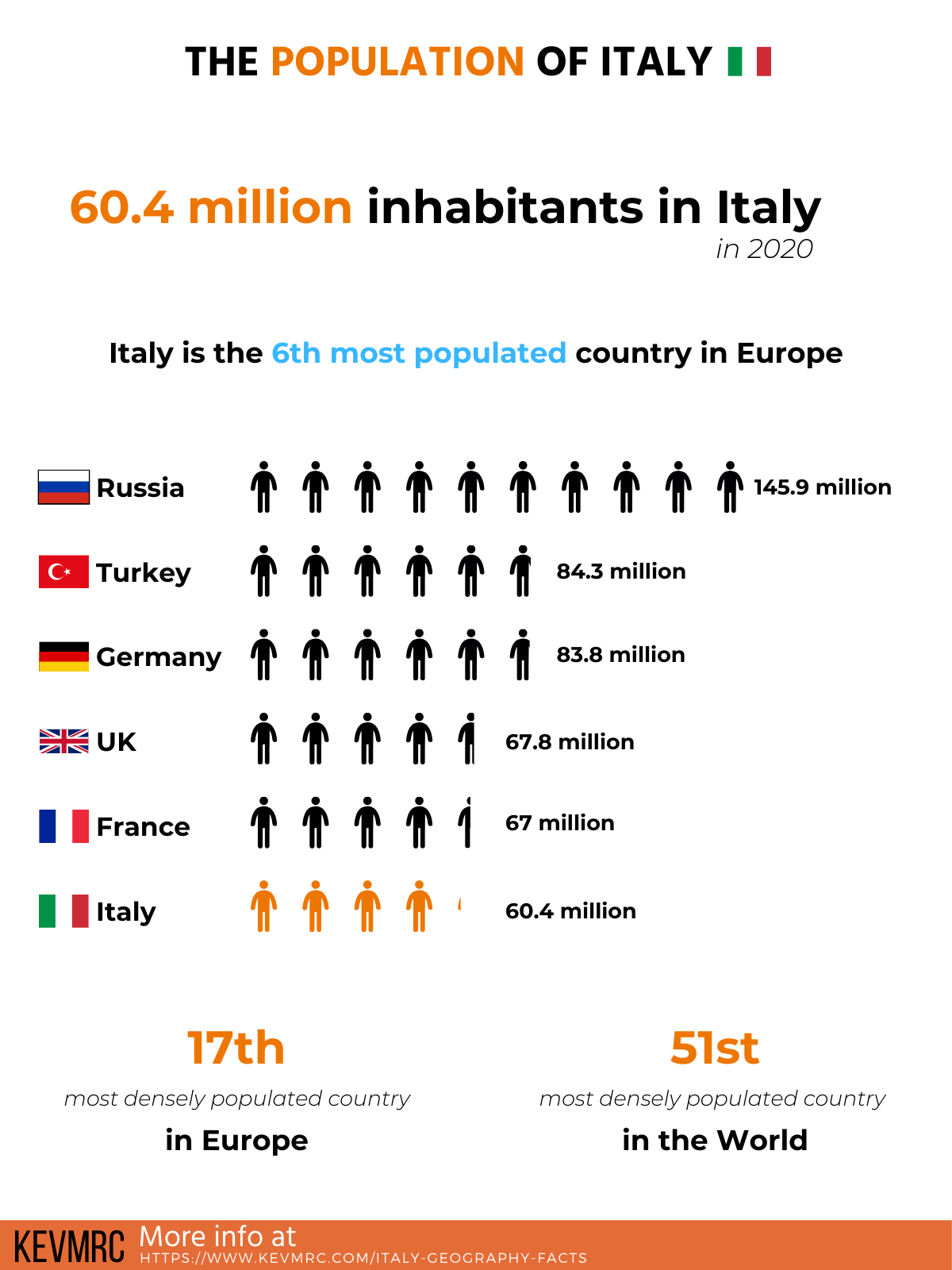
34. There are 60.2 million inhabitants in Italy (2020)
35. Italy is the 6th most populated country in Europe after Russia, Germany, Turkey, France and the United Kingdom
36. With a population density of 200/km² (518/square mile), Italy is the 51st most densely populated country in the world, and 17th in Europe
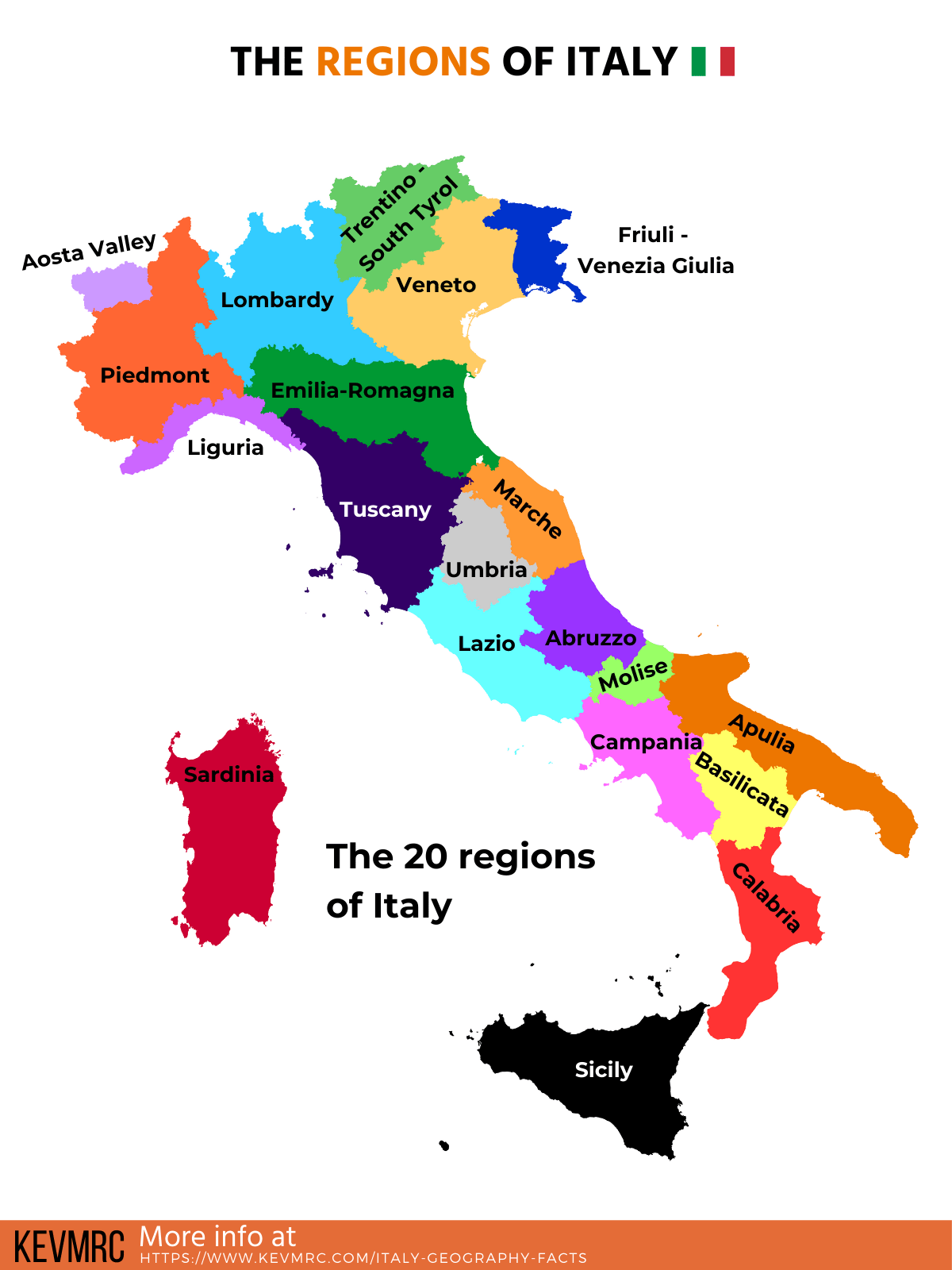
Regions of Italy
This part is dedicated to the regions of Italy: facts, location of all the regions, and ranking of the regions in Italy by area.
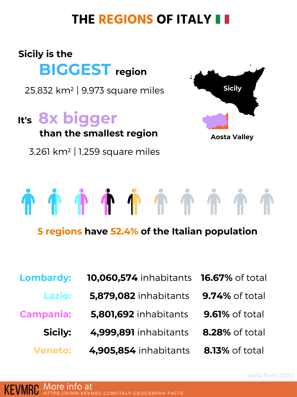
37. Italy is divided in 20 regions
38. The biggest region in size is Sicily, but it’s only the 4th most populated
39. The most populated region in Italy is Lombardy, with 16% of the entire Italian population
40. Aosta Valley is the smallest region in size, and the least populated
41. There are 5 autonomous region with more power than the other regions: Aosta Valley, Friuli-Venezia Giulia, Sardinia, Sicily and Trentino-South Tyrol
The biggest regions in Italy in size:
- Sicily: 25,832 km² | 9,973 square miles
- Piedmont: 25,387 km² | 9,802 square miles
- Sardinia: 24,100 km² | 9,305 square miles
- Lombardy: 23,864 km² | 9,214 square miles
- Tuscany: 22,987 km² | 8,875 square miles
- Emilia-Romagna: 22,453 km² | 8,669 square miles
- Apulia: 19,541 km² | 7,545 square miles
- Veneto: 18,020 km² | 6,958 square miles
- Lazio: 17,232 km² | 6,653 square miles
- Calabria: 15,222 km² | 5,877 square miles
- Campania: 13,671 km² | 5,278 square miles
- Trentino-South Tyrol: 13,606 km² | 5,253 square miles
- Abruzzo: 10,832 km² | 4,182 square miles
- Basilicata: 10,073 km² | 3,889 square miles
- Marche: 9,401 km² | 3,630 square miles
- Umbria: 8,464 km² | 3,268 square miles
- Friuli-Venezia Giulia: 7,924 km² | 3,059 square miles
- Liguria: 5,416 km² | 2,091 square miles
- Molise: 4,461 km² | 1,722 square miles
- Aosta Valley: 3,261 km² | 1,259 square miles
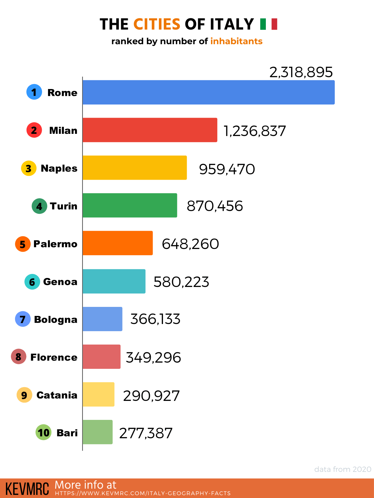
Cities of Italy
This final part of human geography is dedicated to the cities of Italy: facts, location of the main cities, and ranking of the biggest cities in Italy by number of inhabitants.
42. The Italian regions are divided into 96 provinces + 14 metropolitan cities
43. There are 925 cities in Italy with more than 10,000 inhabitants
44. In total, there are 7,904 towns in Italy
45. Rome is the most populous city in Italy, with over 2 million inhabitants in 2020
46. Rome is also the biggest Italian city in area, with 1,285 km² (496 square miles)
47. In Italy, only 2 cities have a population of more than 1 million: Rome and Milan
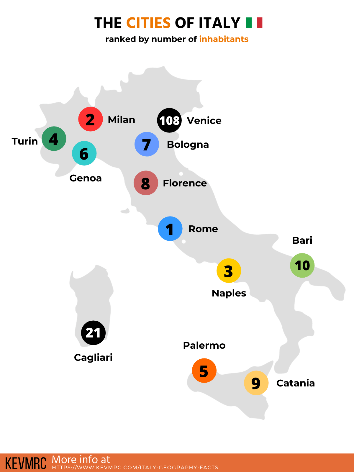
The 10 most populated cities in Italy:
- Rome: 2,318,895 inhabitants
- Milan: 1,236,837 inhabitants
- Naples: 959,470 inhabitants
- Turin: 870,456 inhabitants
- Palermo: 648,260 inhabitants
- Genoa: 580,223 inhabitants
- Bologna: 366,133 inhabitants
- Florence: 349,296 inhabitants
- Catania: 290,927 inhabitants
- Bari: 277,387 inhabitants
So there you have them, the 49 interesting geography of Italy facts!
If you want to see all of the facts in one place, scroll down to see the full list; you’ll also get to see other facts about Italy, such as facts about specific cities or regions.
Italy Flag
More Facts!
Do you want even more facts about Italy?
Check out the following posts:
- Facts about the city of Florence
- Tuscany region facts
- Check out interesting facts about the Amalfi Coast
Or click here to see ALL the facts up on the blog! Spoiler alert: there is A LOT of them.
The Full List of 49 Geography Facts About Italy
- Italy total area is 301,340 km² (116,348 square miles), making it the 10th biggest country in Europe, and 73rd in the world
- 76.8% of Italy is covered by mountains
- 35.2% of the territory is made of mountains over 600m (1,968 feet), and 41.6% of hills (below 600m)
- Only 1.7% of Italy is made of water (lakes, rivers, swamps, …)
- Italy has 7,600 km of coastline (4,722 miles), ranking 15th in the world after Mexico and before India
- Mountains account for 35.2% of Italian territory
- The total border length of Italy is 1,836 km (1,141 miles)
- There are more than 1,000 rivers in Italy
- The most famous river is probably the Tiber river as it passes through Rome, but it’s only the 3rd biggest in Italy
- The longest river in Italy is the Po River, and it’s 652 km long (405 miles)
- There are more than 1,500 in Italy
- Lago di Gardo, or Lake Garda, is the largest lake in Italy; but it’s only the 3rd deepest
- The deepest lake in Italy is Lago di Como, with a depth of 410 meters (1,345 feet)
- Lake Garda belongs to 3 different provinces: Verona, Brescia and Trento
- The longest lake in Italy is Lake Maggiore, with a length of 64 km (40 miles)
- Lake Maggiore is located at 80% in Italy, and 20% in Switzerland
- There are 2 main mountain ranges in Italy: the Alps and the Apennines
- Mont Blanc is the highest mountain in Italy, at 4,808 meters (15,774 feet)
- The Mont Blanc is also the highest peak in Europe
- More than the 150 highest peaks in Italy are all located in the Alps
- The Italian Alps have 3 main parts: Western Alps, Central Alps and Eastern Alps
- The Dolomites, a famous tourist destination, are part of the Eastern Alps
- The Mont Blanc peak is on the border between Italy and France, and belongs to the 2 countries
- The Apennine mountain range is the longest mountain range in Italy, stretching over 1,500 km (932 miles)
- There are 48 volcanoes in Italy
- Mount Etna is the highest volcano in Italy, peaking at 3,329 meters (10,922 feet)
- Italy has 3 active volcanoes: Mount Etna, Mount Vesuvius, and Stromboli
- Mount Vesuvius is the only active volcano in mainland Europe, located next to Naples
- Marsili is the 2nd tallest volcano in Italy, but it’s completely under the sea
- There are around 450 islands in Italy
- Sicily is the biggest island in Italy, and the biggest island in the Mediterranean Sea
- 1/4 of the islands are located in Venice, which is made of 118 islands
- Islands make for 1/6 of the total area of Italy, but only 1/10 of the total population
- There are 60.2 million inhabitants in Italy (2020)
- Italy is the 6th most populated country in Europe after Russia, Germany, Turkey, France and the United Kingdom
- With a population density of 200/km² (518/square miles), Italy is the 51st most densely populated country in the world, and 17th in Europe
- Italy is divided in 20 regions
- The biggest region in size is Sicily, but it’s only the 4th most populated
- The most populated region in Italy is Lombardy, with 16% of the entire Italian population
- Aosta Valley is the smallest region in size, and the least populated
- There are 5 autonomous region with more power than the other regions: Aosta Valley, Friuli-Venezia Giulia, Sardinia, Sicily and Trentino-South Tyrol
- The Italian regions are divided into 96 provinces + 14 metropolitan cities
- There are 925 cities in Italy with more than 10,000 inhabitants
- In total, there are 7,960 towns in Italy
- Rome is the most populous city in Italy, with over 2 million inhabitants in 2020
- Rome is also the biggest Italian city in area, with 1,285 km² (496 square miles)
- In Italy, only 2 cities have a population of more than 1 million: Rome and Milan
- Italy has borders with 6 countries: Austria, France, San Marino, Slovenia, Switzerland and Vatican City
- Italy is surrounded by 5 seas: Adriatic Sea, Ionian Sea, Ligurian Sea, Mediterranean Sea and Tyrrhenian Sea
The Complete Infographic
As promised, you can find below the full infographic, with all the details you saw in this post.
It’s a pretty big file, (and a looooong image), so I’m not putting it directly in the post.
To see the infographic, simply click on this link that will open the full infographic in a new tab.
Share the knowledge!
Click on the buttons below to share these facts with your friends, and help them learn more about the world 🙂

Pin this to Pinterest!
Enjoyed this guide? Then help a fellow traveler and pin it! They'll most definitely love you for it, 100% guarantee.


![23 Interesting Facts About Tuscany, Italy [True Facts]](https://www.kevmrc.com/wp-content/uploads/2016/12/green-hills-of-tuscany-learn-more-about-the-region-with-interesting-facts-about-tuscany-italy.jpg)
Excellent and Imformativ facts.